Satellite-based Rabi rice paddy field mapping in India: A case study on Telangana state
Phenology-driven framework achieving 93.3% accuracy in mapping 732,345 hectares of rice cultivation across Telangana, India.
Phenology-driven framework achieving 93.3% accuracy in mapping 732,345 hectares of rice cultivation across Telangana, India.
A Chrome extension that converts GPS coordinates between formats for Google Earth Engine workflows. Developed to solve a real friction point during rice paddy mapping fieldwork — …
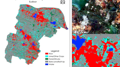
Published Research: This project evolved into a peer-reviewed publication achieving 93.3% accuracy in mapping 732,345 hectares of rice cultivation across Telangana, India. In this …